Bentley Systems Sanjay Gangal
Sanjay Gangal is the President of IBSystems, the parent company of AECCafe.com, MCADCafe, EDACafe.Com, GISCafe.Com, and ShareCG.Com. Bringing Precision to the Field: How Trimble’s MX60 is Transforming Asset Data Capture and GIS IntegrationNovember 27th, 2024 by Sanjay Gangal
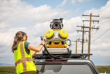
In a cozy, tucked-away corner at the bustling Trimble Dimensions Conference in Las Vegas, I sat down with Karl Bradshaw and Gareth Gibson, both of whom play pivotal roles in shaping the trajectory of Trimble’s geospatial and reality capture technologies. Bradshaw, the Market Manager for Mobile Mapping, and Gibson, the Marketing Director for Mapping & GIS Solutions, came armed with an infectious enthusiasm and an array of details about Trimble’s latest innovation: the Trimble MX60. It was clear from our conversation that for them, the MX60 wasn’t just another product—it was a leap forward in the way we understand and interact with the physical world around us.  The Trimble MX60 offers improved positioning and optics, making it ideal for transportation infrastructure and road analysis and comprehensive asset management for utilities. Bradshaw wasted no time in setting the stage. “Reality capture has evolved tremendously within Trimble,” he began. “We’re moving beyond static methods and into a realm where the devices do much of the heavy lifting. With the MX60, we’ve created a platform that collects mass data and makes it available for a range of practical applications.” He elaborated on how the MX60’s mobile mapping capabilities allow it to capture high-definition images and detailed 3D point clouds with stunning accuracy. The camera system, he emphasized, was a key development for utility companies, municipalities, and other sectors dependent on reliable asset data. Trimble’s Visionary Keynote Champions Connection and Innovation in the Construction Industry’s New Digital EraNovember 14th, 2024 by Sanjay Gangal
Las Vegas — Against a backdrop of rapid technological advancement, Trimble’s CEO delivered a powerful keynote at this year’s Trimble Dimensions conference in Las Vegas, presenting a vision for the future of construction and design centered on connection and transformation. Rob Painter set the stage with a compelling metaphor, drawing a parallel between Trimble’s journey and the relentless progression of the Olympic Games, where world records are shattered, new techniques are introduced, and the very definition of excellence is redefined with each passing year. Painter invited the audience to imagine 1988, the Summer Olympics in Seoul, where American sprinter Carl Lewis took gold in the 100 meters with a time of 9.92 seconds. Fast forward to the most recent games in Paris: the last-place finisher in this year’s 100-meter race crossed the line faster than Lewis’s record-breaking time. This moment, Painter argued, encapsulates the dizzying pace of advancement not only in sports but in the world of construction and design as well. “Even if you’re at the top of your game today, one year—or one moment—might not be enough to keep you there,” he said. In a world moving as fast as ours, companies must keep pace with change or risk falling behind.
This year, Trimble framed its strategy around what it called the “power of connection.” Using the Olympics as a metaphor for continually rising standards, Painter urged attendees to embrace an industry redefined by digital connections, integrated workflows, and artificial intelligence. “The power of connection is the core of this revolution,” he emphasized, outlining Trimble’s plans to link people, data, workflows, and ecosystems into a connected digital fabric that will underpin the construction industry’s future. Esri and Autodesk Push the Boundaries of AECO Design with Groundbreaking Integration of ArcGIS Data into Autodesk FormaNovember 6th, 2024 by Sanjay Gangal
In a significant stride toward unifying the architecture, engineering, construction, and operations (AECO) sector, Esri and Autodesk have taken their collaboration to new heights by integrating Esri’s ArcGIS geospatial data directly into Autodesk Forma. The integration, announced at the 2024 Autodesk University in San Diego, brings transformative enhancements to the design and planning phases of AECO projects, arming professionals with precise geographic data to inform critical early decisions. This groundbreaking partnership promises to reshape the way buildings and infrastructure are conceived and constructed. The announcement comes at a pivotal moment when AECO professionals are increasingly relying on digital tools to navigate the complexities of modern urban design. Traditionally, planners, architects, and engineers have had to juggle multiple platforms, often resulting in disjointed workflows and data loss between tools. This new integration of Esri’s comprehensive spatial data into Autodesk Forma addresses those inefficiencies head-on, creating a seamless experience that allows AECO professionals to access real-time geographic data from the outset of any project. “Forma represents a new foundation for Autodesk in the 2020s, potentially akin to the impact AutoCAD had in the 1990s,” said Marc Goldman, AEC Industry Director at Esri, during our conversation at Autodesk University. He noted that incorporating ArcGIS data in Forma bridges critical gaps in the planning process. “The partnership between Esri and Autodesk is transformative. It combines the power of GIS and BIM in a way that allows teams to start projects with comprehensive geographic context—something that has been sorely lacking in the past,” Goldman emphasized. Harnessing the Power of AI: Nearmap’s Pioneering Gen 6 at Autodesk UniversityOctober 24th, 2024 by Sanjay Gangal
At the heart of San Diego’s Autodesk University, innovation was in full display as Nearmap, a global leader in location intelligence and aerial imagery, unveiled their latest technological breakthrough—Gen 6 AI. In an exclusive interview, Jeff Saunders, Director of Product Management, and Steve Santovasi, Director of Product, took the time to share how Nearmap’s advancements are transforming industries with unparalleled precision and efficiency. With the release of their sixth generation AI technology, Nearmap is pushing the boundaries of what’s possible in geospatial intelligence. “We’ve got over 180 layers of data and attributes that we’re gathering from our vertical captures,” Saunders shared. But this isn’t just about amassing data—it’s about turning that data into actionable insights that have the power to reshape decision-making across industries.  Showcases different AI packs and layers including: Buildings & Vegetation, Hard Surfaces, Pole detection and Pavement damage. From civil engineering to asset management, and government to insurance, Nearmap’s Gen 6 AI is providing businesses with the tools they need to streamline workflows, minimize risks, and anticipate needs long before issues arise. Read the rest of Harnessing the Power of AI: Nearmap’s Pioneering Gen 6 at Autodesk University Bentley Systems CEO Nicholas Cumins Charts AI-Driven Future at Year in Infrastructure ConferenceOctober 12th, 2024 by Sanjay Gangal
Vancouver, Canada — Nicholas Cumins, CEO of Bentley Systems, delivered a captivating keynote on the second day of the Year in Infrastructure (YII) Conference, setting the tone for the industry’s future by outlining a bold vision where artificial intelligence (AI), open data ecosystems, and digital twins reshape global infrastructure. Against the vibrant backdrop of Vancouver, Cumins emphasized the importance of leveraging advanced technologies to meet today’s challenges and create more resilient, sustainable systems. “Vancouver, with its long history of balancing the built and natural environment, serves as the ideal inspiration,” Cumins remarked. He reflected on Bentley Systems’ four-decade journey from its inception in 1984 to its current role as a global leader in infrastructure engineering software. As the world faces unprecedented demand for better infrastructure, Cumins framed Bentley’s mission as a call to unlock the potential of data, streamline collaboration, and accelerate sustainability.
Bentley’s Legacy: Transforming Infrastructure Design and OperationsCumins began by walking the audience through Bentley’s history, tracing the company’s origins back to when Keith Bentley saw the potential of personal computers to revolutionize engineering software. Bentley’s flagship product, MicroStation, democratized CAD (computer-aided design) software, allowing engineers to work more efficiently and precisely. As technology advanced, so did Bentley’s tools, evolving from 2D to 3D modeling and ultimately to 4D construction modeling through Synchro, which enables engineers to manage construction schedules and monitor progress in real-time. Cumins highlighted Bentley’s innovations in digital twins, dynamic replicas of infrastructure assets that continuously update with real-time data. “Digital twins allow engineers to monitor and optimize infrastructure throughout its lifecycle,” he explained, “ensuring assets perform efficiently, reducing maintenance costs, and improving safety.” Benesch Harnesses the Power of AI, Machine Learning, and Infrastructure Digital Twins to Industrialize Pavement ManagementSeptember 2nd, 2024 by Aude Camus
Leveraging Bentley Infrastructure Cloud and iTwin Technology Streamlines Workflows and Facilitates Data-centricity to Save over 75% of Manual Field Work Project Summary Organization: Benesch Solution: Surveying and Monitoring Location: United States Project Objectives:
Project Playbook: iTwin, iTwin Capture Fast Facts
ROI
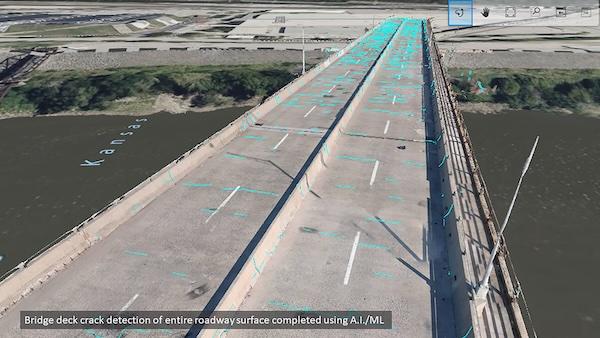
Pushing Technology Boundaries for Pavement Assessment Workflows Most civil infrastructure assets—including bridges, transport networks, and airport runways—include pavement, requiring crack detection survey and maintenance to ensure the safety and longevity of these structures. However, current traditional pavement assessment practices and data collection methods are costly, time consuming, and result in shutdowns that negatively impact infrastructure owner-operators, as well as the public. “Our clients struggle with the amount of time that it takes consultants to close their assets down, and current methods for collecting cracking and joint data take too long,” said Bret Tremblay, technical manager at Benesch, a multidiscipline engineering firm offering services across a broad range of civil infrastructure markets. In addition, the on-site inspections and analyses would not be conducted for the entire pavement, but rather across sample sections, providing general insight into existing area damage and a projected average for defects throughout the rest of the asset. While this approach opens the door to quantity overruns and change orders, it has become standard industry practice.  Courtesy 1: Benesch explored integrating AI/ML and digital twins for a more data-centric, automated pavement detection workflow. Image courtesy of Benesch. WSP Australia Drives Innovation in Enterprise Engineering to Meet Evolving Industry DemandsAugust 26th, 2024 by Paul Rotter
ProjectWise and iTwin Facilitates Data-centric Workflows via Digital Twins for More Intelligent Sustainable Infrastructure Project Summary Organization: WSP Australia Project Objectives:
Project Playbook: Bentley Infrastructure Cloud, iTwin, MicroStation, OpenBridge, OpenBuildings, OpenCities, OpenRail, OpenRoads, ProjectWise, SYNCHRO Fast Facts
ROI
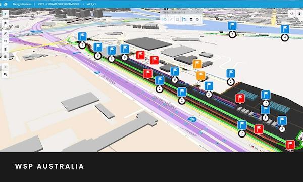
Searching for Data-centric Project Delivery Methods WSP Australia is committed to providing a transformative enterprise engineering journey by building trust in digital applications and processes to optimize project delivery across all business sectors. The organization embraces the latest technologies, fostering a culture of innovation. “There is a growing need for integrated digital solutions on major infrastructure projects, with all participants seeing increased efficiency, collaboration, and reduced cost,” said Alexander Yammas, regional digital engineering lead at WSP. The organization initially embarked on their digitization initiatives back in 2017 when they were faced with disparate information and project management hurdles. At that point, they introduced ProjectWise on a project-by-project basis and, in 2021, utilized the application to link multisourced data and 250 team members on their Port Rail Transformation Project (PRTP) in Melbourne, Australia.  WSP Australia sought to utilize cutting-edge technology to streamline data management while building trust in new digital workflows. Image courtesy of WSP Australia. “Fast forward to 2023, ProjectWise has become a business-as-usual application that is employed in over 150 active projects, with more than 2,000 active users,” said Bob Freeman, WSP’s information management lead. Now with digital twins and artificial intelligence (AI) at the forefront of delivering intelligent infrastructure, WSP is seeking to implement smart, data-centric digital workflows and strategies to make better decisions and deliver better outcomes. WSP is prioritizing this organizational shift, harnessing the power of cutting-edge technologies to implement a holistic approach, streamlining data management and workflows within the transportation division while supporting widespread intelligent digitization in enterprise engineering. Dublin City University Seeks to Advance Infrastructure Digital Twins by Testing AI for Smart City InnovationsAugust 16th, 2024 by Prathamesh Gawde
Bentley Infrastructure Cloud and iTwin Technology Helped Streamline Digital Data Integration and Improve Visualization Project Summary Organization: Dublin City University Solution: Facilities, Campuses, and Cities Location: Dublin, Ireland Project Objectives:
Project Playbook: AssetWise, iTwin, iTwin Capture Fast Facts
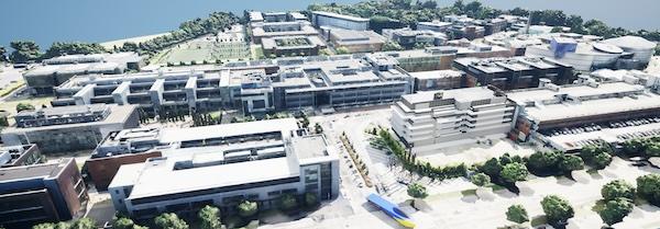
Callout Quote: “By utilizing the Bentley ecosystem, we were able to create a detailed 3D model of the university campus and integrate diverse IoT data feeds from various vendors in a fast, efficient manner.” – Kieran Mahon, Smart DCU Project Facilitator, Dublin City University  Image caption/courtesy 1: Dublin City University (DCU) is collaborating with Bentley Systems to create a campus digital twin as part of its Smart DCU initiative. Image courtesy of Dublin City University.Collaborating on the Future of Infrastructure Digital Twins Understanding that digital twins are the future of infrastructure, Dublin City University (DCU) teamed up with Dublin City Council, Insight SFI Research Centre for Data Analytics, and Bentley Systems to push the boundaries of digital twins. DCU sought to advance its existing Smart DCU program, which is utilizing the university campus as a test site to explore and evaluate the latest advancements in smart city solutions. This collaborative initiative will investigate the power of artificial intelligence (AI) and immersive digital twin technology using DCU as a city microcosm for developing intelligent and sustainable urban spaces. |
|
|
|||||
|
|
|||||
|
|||||


